
Living in Merritt Island, FL: the honest waterfront & boating guide
Merritt Island is where Space Coast buyers go for a real waterfront house with a dock, deep-water or canal access, and a short run to Kennedy Space Center. The cost people underestimate is the waterfront one: the dock, the seawall, the flood zone, the insurance. This guide gives you the real cost and the real fit before you commit.
Merritt Island, FL in brief
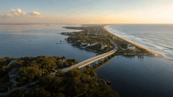
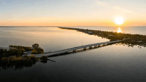
Merritt Island is a large island in Brevard County, between the Indian River and the Banana River, connected to Cocoa and the beaches by causeways. It is the Space Coast's waterfront-and-boating community, with canal-front and deep-water homes, plus Kennedy Space Center and a national wildlife refuge at its north end.
| Setting | Island between the Indian River and Banana River lagoons |
| North end | Kennedy Space Center and Merritt Island National Wildlife Refuge |
| Connected via | SR-520 and SR-528 causeways to Cocoa, Cocoa Beach, and the Port |
| Best for | Waterfront houses, dockage, boating, KSC/Cape commuters |
What Merritt Island actually is
If Cocoa Beach is the walkable condo town, Merritt Island is its counterpart for people who want a house, a yard, and a boat. It sits between two lagoons, so canal-front and river-front homes with private docks are the signature inventory, and deep-water access for boaters is the prize. The north end is dominated by Kennedy Space Center and the Merritt Island National Wildlife Refuge, which keeps much of it green.
It also tends to offer strong relative value for waterfront on the Space Coast: it pairs real waterfront demand with a shorter commute to the Cape than most realize. The honest trade-off is that waterfront ownership adds real, ongoing costs, which is exactly what the next section covers.
A dock and deep water are worth a lot here. Just price in the seawall, the flood zone, and the insurance before you sign.
Merritt Island waterfront areas
Sykes Creek & Newfound Harbor
Canal and creek-front pockets prized for dockage and protected boating access on the Banana River side. We label these as areas, not platted subdivisions. See waterfront homes.
Diana Shores & North Merritt Island
Established waterfront and larger-lot homes, with the quieter, greener north end toward the wildlife refuge. See North Merritt Island homes.
Tropical Trail corridor
North and South Tropical Trail are scenic river-road corridors (not subdivisions) lined with riverfront homes and oak canopy along the Indian River. See riverfront homes.
Use the saved-search filters on the Merritt Island listings page to narrow by waterfront type (canal, river, deep-water), dockage, and price. Specific community and plat names are confirmed against the MLS before they are featured.
The real cost of waterfront ownership
Waterfront is the reason to buy here, and it carries costs a non-waterfront home does not. None of this should scare you off; it should be in your budget before you fall in love with a dock.
Docks, seawalls & lifts
Docks, boat lifts, and seawalls need permitting, maintenance, and eventual replacement, and seawall repair is not cheap. Have the dock and seawall inspected, and confirm what permits exist, before you buy.
Flood zones & elevation
Waterfront and low-lying lots commonly sit in FEMA flood zones; an elevation certificate can change your premium a lot. Verify the exact zone at the FEMA Flood Map Service Center.
Insurance: wind + flood
On the island these are separate policies, and both run higher than mainland. Get real quotes for the specific home early. Background: Florida Office of Insurance Regulation and Citizens.
Deep water vs. fixed bridges
"Waterfront" is not all equal. Confirm controlling depth and whether fixed bridges limit your boat's access to the Banana River, the Intracoastal, and the ocean. Storm/surge context: NOAA / National Hurricane Center.
Talk with Brianna about waterfront costs first
General education, not professional advice. Confirm specifics with a licensed insurance, marine-survey, tax, or legal professional.
Schools
Merritt Island is served by Brevard Public Schools; assignment is by address, so confirm the zoned schools for any specific home rather than assuming by area. We describe schools by program and logistics, not as quality rankings, so you can decide what fits your family.
Commute, the Cape & KSC
Merritt Island connects to the mainland (Cocoa) and the beaches via the SR-520 and SR-528 causeways, and SR-3 runs the length of the island to the north-end space facilities. The commute to Kennedy Space Center and Cape Canaveral Space Force Station is short, which makes the island popular with aerospace and defense workers. For military and aerospace relocation, see the Space Coast relocation guide.
Boating, fishing & nature
The island is a boater's and angler's home base, with the Banana and Indian River lagoons, Sykes Creek, and Kiwanis Island Park. The Merritt Island National Wildlife Refuge and adjacent Canaveral National Seashore protect vast areas of coastal habitat, and the barrier-island beaches are a causeway away.
Who Merritt Island is for, and who it isn't
A strong fit if you want
A waterfront house with a dock, deep-water or canal boating access, more space and yard than the beach towns, and a short commute to the Cape, with eyes open about dock and insurance costs.
It may not fit if you want
To walk to the ocean (look at Cocoa Beach), the lowest entry price or brand-new construction (look at Palm Bay), or to skip waterfront upkeep entirely (then a non-waterfront mainland home in Melbourne fits better).
Merritt Island vs. its neighbors
| Community | Best for | Trade-off |
|---|---|---|
| Merritt Island | Waterfront houses, dockage, boating, KSC commute | Dock/seawall/flood costs; not walkable-to-beach |
| Cocoa Beach | Walkable beach life, oceanfront condos, surf | Condo reserves/assessments; smaller lots |
| Melbourne | Mainland value, jobs, downtown/arts | Beach is a causeway away |
The Merritt Island market, live
Rather than print a number that goes stale, this guide links to live data: active waterfront and non-waterfront inventory, average sold price, and days on market, pulled straight from the MLS. See the Merritt Island market snapshot. Regional context is published by the Space Coast Association of REALTORS®.
Merritt Island FL real estate FAQ
What county is Merritt Island in?
Merritt Island is in Brevard County, on Florida's Space Coast, on the large island between the Indian River and the Banana River.
Is Merritt Island a good place to live?
For waterfront and boating buyers, it is one of the best fits on the Space Coast: canal and river homes with docks, more space than the beach towns, and a short commute to Kennedy Space Center. The honest caveat is that waterfront ownership adds dock, seawall, flood, and insurance costs you should budget for.
Is Merritt Island good for boating and waterfront homes?
Yes, that is its signature. The island sits between two lagoons, so canal-front, river-front, and deep-water homes with private docks are common. The key is to confirm controlling depth and whether any fixed bridges limit your boat's access to open water before you buy.
What does a waterfront home on Merritt Island really cost to own?
Beyond the purchase price, budget for dock, boat-lift, and seawall maintenance and eventual replacement, flood insurance based on the FEMA zone, and higher wind insurance on the island. Have the dock and seawall inspected and get real insurance quotes for the specific home before you commit.
How far is Merritt Island from the beach?
The barrier-island beaches at Cocoa Beach are a short causeway drive east via SR-520. Merritt Island itself is not oceanfront; its water is the Indian and Banana River lagoons, which is what makes it a boating community rather than a beach-walking one.
What is the commute to Kennedy Space Center from Merritt Island?
Short. SR-3 runs the length of the island to the north-end space facilities, and Kennedy Space Center and Cape Canaveral Space Force Station are a quick drive, which is why the island is popular with aerospace and defense workers.
Is Merritt Island safe?
Like anywhere, it varies by area. Rather than label places as good or bad, tour at different times and review current, address-level information. Brianna can walk you through specific areas and waterfront pockets candidly.
Where are the best waterfront areas on Merritt Island?
It depends on your boating needs: Sykes Creek and Newfound Harbor for protected canal access, North Merritt Island and Diana Shores for established waterfront and larger lots, and the Tropical Trail corridor for riverfront along the Indian River. There is no single best, only the best fit for your boat and budget.
Data last verified: June 2026. Always confirm current market figures, flood zones, insurance quotes, dock/seawall condition, and controlling depth for the specific property.
About Brianna
Brianna Lalumiere is a Broker Associate with Nautical Lifestyle, eXp Realty, LLC (FL License #3332138), serving buyers and sellers across Florida's Space Coast, including Merritt Island waterfront and boating homes. She is an eXp Realty Icon Award recipient for 5+ consecutive years and has been serving Space Coast clients since 2015. Reach her at (727) 641-3957 or briannarealtor@gmail.com.
REVIEWS

Brevard Home Repairs Renovations

Jackie Clark

Monica Iannaccone
MY BLOGS
GET MORE INFORMATION